
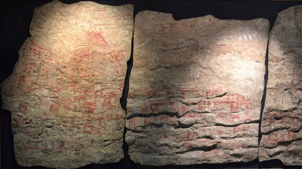
Long before satellites or cartographers, a Neolithic community in what is now central Türkiye created something extraordinary: a map—arguably the first in human history—not drawn on parchment or stone, but painted on the interior wall of a mudbrick house. This wall painting, measuring about 3 meters in length and 90 centimeters in height, is believed to depict the settlement of Çatalhöyük, with a double-peaked volcano—likely Mount Hasan—looming in the background.
Estimated to be 8,200 years old, this mural reflects early humans’ spatial awareness, community structure, and possibly their spiritual relationship with the land. Radiocarbon dating suggests it was created around 6200 BCE (±97 years).
More Than a Map: A Cultural and Symbolic Statement
Located in the Konya Plain of central Anatolia, Çatalhöyük is one of the most significant and best-preserved Neolithic sites in the world. First excavated in 1958 by archaeologist James Mellaart, the site reveals a society that thrived between 7400 and 5200 BCE—an era that marked the transition from hunting-gathering to settled agricultural life.
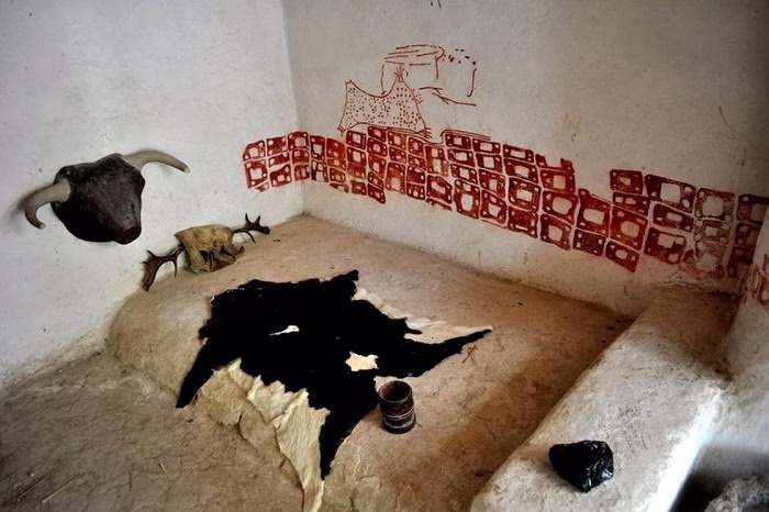
But Çatalhöyük was no ordinary village. It had:
- No streets—residents walked over flat-roofed homes
- Entrance through rooftops, not doors
- Communal values with little sign of social hierarchy
- Symbolic and spiritual art, including bull horns, geometric patterns, and burial rituals
- Houses with burials beneath the floor, showing ancestor worship and complex mortuary practices
The mural interpreted as a map may also carry symbolic or ritualistic meaning, reinforcing the site’s layered cultural significance.
Mount Hasan and Volcanic Memory
In the mural, the two conical shapes behind the clustered rectangles of buildings are widely thought to represent Mount Hasan, a dormant volcano near Çatalhöyük. Some archaeologists interpret this as the earliest known visual record of a volcanic eruption, making the mural not only a map but potentially the first natural disaster illustration in history.
Whether literal or symbolic, the depiction links the people of Çatalhöyük to their physical environment in a uniquely expressive way.
Ongoing Research at a Global Heritage Site
Since 1993, the excavation of Çatalhöyük has been led by international teams, most notably under the direction of Prof. Ian Hodder from Stanford University. Following Hodder’s tenure, the responsibility was transferred to Prof. Dr. Ali Umut Türkcan of Anadolu University, who currently oversees archaeological research at the site.
Çatalhöyük consists of two mounds: the East Mound, with 18 layers of Neolithic occupation (c. 7400–6200 BCE), and the West Mound, containing layers from the Chalcolithic Period (c. 6200–5200 BCE).
In 2012, UNESCO designated Çatalhöyük as a World Heritage Site, recognizing its significance in the development of early urban life, communal organization, and symbolic culture.
A Timeless Legacy in Mud and Paint
The mural from Çatalhöyük is more than an archaeological curiosity. It is a testament to early human cognition, creativity, and connection to the world around them. It shows that even 8,000 years ago, people not only understood the geography of their surroundings—they were compelled to express it, preserve it, and possibly even ritualize it.
In this single painted wall, we glimpse the origins of mapping, memory, and meaning—a whisper from the deep past, still speaking through the earth.


