A 160-meter-long rectangular structure, discovered in 1959 on the southern slope of Mount Ararat and long speculated to be Noah’s Ark, is once again under scientific scrutiny. The U.S.-based research group Noah’s Ark Scan will launch excavations to determine whether the formation is natural or man-made.
The California-based team is collaborating with local Turkish universities to conduct radar scans and geological analyses of the region. They also aim to develop a site conservation plan.
First Discovery Made in 1959 Through Aerial Photography
The site was first identified in 1959 by Captain İlhan Durupınar, a cartographic engineer. While analyzing aerial photographs taken around Mount Ararat for mapping purposes, he noticed a ship-like shape between the villages of Telçeker (Sürbehan) and Üzengili (Meşar).
Nezih Başgelen: “This Area Is One of the Most Well-Known Sites Associated with the Flood Legend”
Archaeologist and Director of the Platform for Monitoring Cultural and Natural Heritage, Nezih Başgelen, emphasized the site’s historical and cultural significance:
“From legends to theological traditions, Mount Ararat is one of the most commonly associated locations with Noah’s Ark and the story of the Great Flood. In the Torah, the Ark is said to have landed on ‘Ararat,’ while the Quran mentions ‘Cudi’.”

Başgelen added that the first field studies of the structure began in 1960, attracting international attention:
“Initial surveys were carried out in 1960. Reports published in Hayat magazine, along with photographs taken by renowned photographer Ara Güler, brought global awareness to the site.”

Dimensions Closely Match Biblical Descriptions
Başgelen noted that Captain Durupınar’s measurements of the site closely matched those given in the Torah:
“When Durupınar calculated the dimensions of the shape in the photograph, they corresponded exactly with those described in the Torah for Noah’s Ark. Following this sensational discovery, the World Council of Churches sent a six-member team to inspect the site on June 3, 1960. Their findings were featured in Hayat magazine’s July 22, 1960 issue under the headline ‘Is This Noah’s Ark?’”
New Radar Scans Reignite Scientific Interest
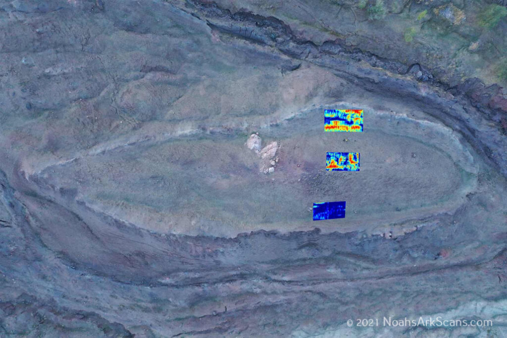
The Noah’s Ark Scan team recently revealed that radar imaging had uncovered a rectangular structure buried a few meters beneath the surface. Measuring 160 meters in length and situated within a smooth, oval-shaped hill, the formation aligns closely with Ark descriptions.
“We will conduct systematic excavations to determine whether the structure is artificial. The findings could be significant both scientifically and culturally,” said members of the research team.
Site Protected Since 1989 as a Natural Heritage Area
American researcher Ron Wyatt conducted extensive radar scans of the area in the 1980s, publishing his results in the book Discovered Noah’s Ark. These developments led Turkey’s Ministry of Culture and Tourism to designate the site a natural protected area in 1989.
Recalling his own field experience, Başgelen stated:
“In 1985, during my military service, I visited the site upon the request of the commander of the 9th Corps. I believe the ship-like formation may have shifted down the slope over time.”
Open to Speculation, But Science May Soon Offer Clarity
Başgelen emphasized that although the subject has long been open to speculation, modern technologies could now yield more definitive results:
“This topic has always attracted attention and speculation. But today, with the help of drone technology, LIDAR scanning, ground-penetrating radar, and lab analyses, we can now acquire much more reliable and comparative data.”
Cover Image Credit: Rob Scholte Museum