
A team of researchers has digitally reconstructed medieval travel routes across England and Wales, revealing how Roman roads influenced mobility for over a millennium after the empire’s fall.
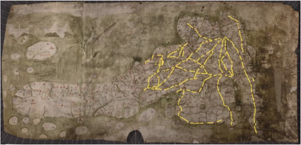
Historians and digital archaeologists have created a groundbreaking Geographic Information Systems (GIS) database based on the mysterious 15th-century Gough Map, which depicts England and Wales with intricate red lines. These lines, long debated, are now understood as genuine medieval roads connecting towns, rivers, and regions—making the Gough Map the earliest known representation of Britain’s complex overland network.
Tracing the Legacy of Roman Roads in Medieval Britain
By analyzing archaeological, linguistic, documentary, and environmental evidence, the team compared these medieval routes with surviving Roman roads. Their findings reveal a varied legacy: some Roman routes, such as those in the Thames Valley, declined due to shifts toward river travel and political changes. Conversely, cities like London, Winchester, and Leicester—which preserved their Roman cores—show strong alignment between Gough Map routes and ancient Roman infrastructure.

Where Roman towns were abandoned or replaced, including Old Sarum (later Salisbury) and Venta Icenorum (near modern Norwich), road continuity weakened or disappeared. The researchers emphasize that no single factor explains this; rather, road survival depended on a complex mix of political, geological, economic, and localized human choices.
From Ancient Maps to Digital Insights
Building on previous digitization efforts, this study presents a new open-access GIS database capturing the Gough Map’s travel networks digitally. Beyond historical interest, the project demonstrates how combining ancient maps with modern technology can uncover broad socio-economic patterns influencing medieval movement, trade, and communication.
This work also aligns with pan-European initiatives like Viabundus and Itiner-e, which seek to digitally reconstruct historical travel routes across borders, promising to revolutionize studies of mobility and infrastructure from antiquity through the early modern period.
A Millennium of Roads and Human Decisions
Ultimately, the research reshapes our understanding of medieval travel. The endurance of ancient routes was not dictated solely by empire or economy but by countless micro-decisions made by people navigating their environment—choosing paths influenced by terrain, agriculture, politics, safety, and settlement patterns.
By revealing how these decisions unfolded over centuries, the study not only recovers lost pathways but reconnects us to the lived geography of the past.
Eljas Oksanen, Stuart Brookes, The afterlife of Roman roads in England: insights from the fifteenth-century Gough map of Great Britain. Journal of Archaeological Science. Volume 179, July 2025, 106227. doi.org/10.1016/j.jas.2025.106227
Cover Image Credit: Facsimile of the Gough Map by the Ordnance Survey. First published in 1870, the red transcriptions of ancient names were added in the 1935 edition. Credit: Public Domain


