
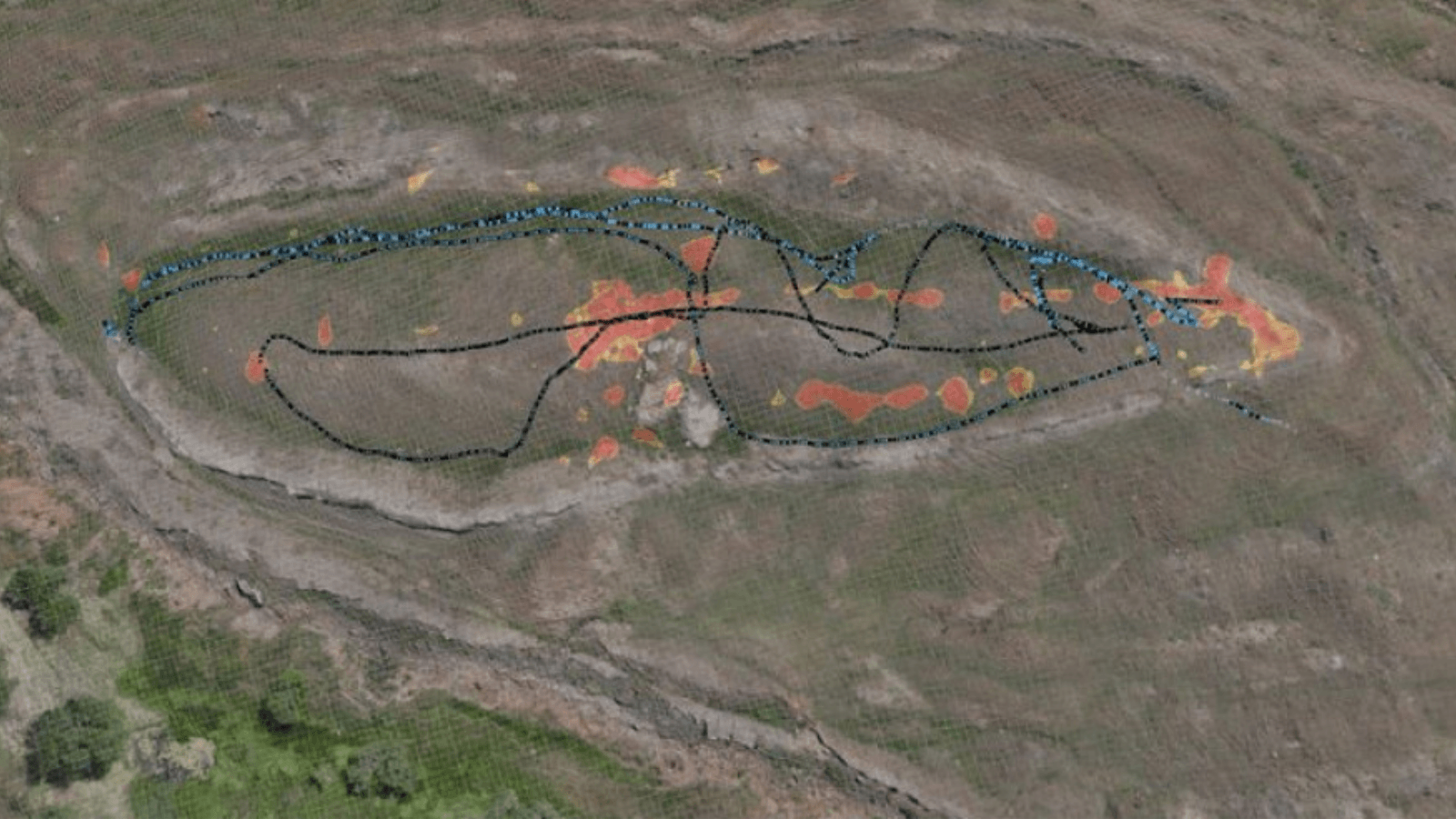
A radar built to find military tunnels and buried objects is now testing what lies beneath Turkey’s Noah’s Ark-shaped Durupınar Formation. Its first survey identified angular anomalies and possible cavities, giving researchers new targets for physical sampling.
Known as BakhtarRadar, the technology emerged from research supported by the US Air Force. Its deployment at Durupınar has inevitably revived claims surrounding Noah’s Ark, but the scans have not revealed a ship. The real question is whether the system can distinguish an ancient human-made structure from the complicated geology beneath the site.
What does a tunnel-hunting radar actually see?
BakhtarRadar was developed to locate hidden objects, voids and underground structures. Related technology has been used to reconstruct clandestine tunnels beneath the US–Mexico border.
Dr. Khosrow Bakhtar led the survey at Durupınar, working with an international team headed by Prof. Dr. Cenker Atila of Sivas Cumhuriyet University.
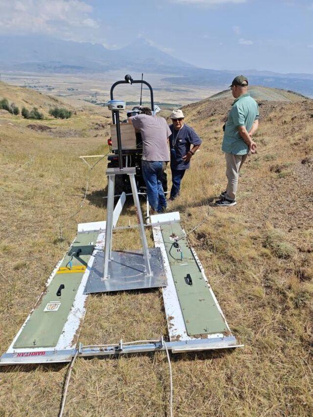
Instead of producing a photograph of what lies underground, the system records changes in the physical properties of subsurface materials. The resulting data can reveal boundaries, discontinuities and areas that differ from their surroundings.
At Durupınar, some signals reportedly form relatively straight lines or intersect at sharp angles. Project researchers have compared them with possible chambers or internal divisions.
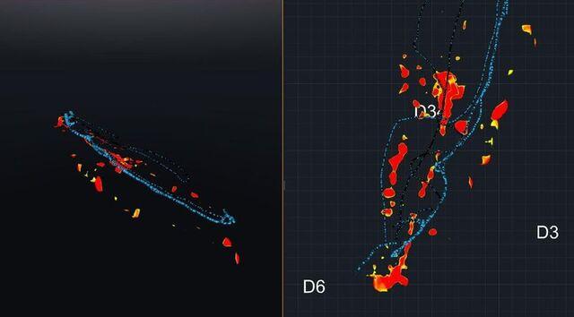
That interpretation remains untested. A right angle on a radar visualization is not automatically a wall, deck or room. Geological fractures, contrasting sediment layers, moisture and mineral deposits can all produce distinct signals. Data processing may also make irregular underground features appear more orderly when presented as a two-dimensional image.
The radar’s immediate value is therefore practical: it identifies places where drilling may provide an answer.
Durupınar’s strongest evidence has always been its shape
The formation lies near Üzengili village in Ağrı Province, south of Mount Ararat. It became widely known after Turkish Army Captain İlhan Durupınar recognized its unusual outline in aerial survey photographs in 1959.
Viewed from above, the landform resembles a ship’s hull. It has a long central body, raised margins and a pointed end. Its reported length of approximately 157 metres has frequently been compared with estimates derived from the dimensions of Noah’s Ark in the Book of Genesis.
Its outline is visually persuasive, but shape alone cannot establish that the formation was constructed or modified by people.
Any archaeological interpretation must therefore survive a harder test: Does Durupınar contain material or structural evidence that natural geology cannot adequately explain?
Earlier investigations reached a geological conclusion
Durupınar has undergone repeated surveys, limited drilling attempts and geophysical investigations since the second half of the 20th century.
Previous geological research concluded that the ship-like form developed through natural processes involving folded sedimentary layers, erosion and earth movement. Features presented as traces of metal fastenings were interpreted as concentrations of iron-bearing minerals. Objects described as petrified wood were also identified as natural rock.
Those investigations did not find a wooden hull, worked timber or an archaeological structure.
The new research must consequently do more than locate empty spaces or unexpected lines. It must show that the anomalies cannot be explained by the local geology and then connect them with physical material shaped by human activity.
BakhtarRadar was brought to the site partly to map deeper layers and clarify where the formation meets the underlying bedrock. If the entire feature consists of naturally deformed sediments resting on an identifiable geological base, the radar may help illustrate how it formed. If it contains materials arranged in a way that geology cannot explain, drilling should provide the first physical indication.
The carbon claim needs more information
The project has also reported a potentially intriguing difference between soil samples.
According to Atila, preliminary testing found approximately 40 percent more carbon in samples from an area identified as the formation’s interior than in material collected outside it. Researchers suggested that the difference might reflect organic matter, including the possibility of degraded wood.
The available information is not detailed enough to support that conclusion.
The university announcement did not state how many samples were compared, which form of carbon was measured or what analytical procedure was used. Soil carbon can originate from plant roots, microorganisms, surface vegetation and sediments transported by water. Differences in drainage conditions may also create substantial variations across a single landform.
Before the result can carry archaeological significance, researchers will need to demonstrate that the carbon pattern is consistent, explain how it relates to the formation’s layers and identify the material responsible for it.
The team plans to collect approximately 1,000 soil and rock samples, which should provide a much broader basis for comparison.
What would count as real evidence?
More radar images will not settle the Durupınar debate. Physical samples might. Elsewhere in eastern Anatolia, ground-penetrating radar helped locate a Roman bathhouse that was later confirmed through excavation, showing why remote-sensing signals must be physically tested before they can be treated as archaeological evidence.
Researchers plan to combine the new scans with electrical resistivity measurements, three-dimensional terrain mapping and laboratory analysis. They will then drill selected anomalies and extract narrow cores containing sequences of soil, sediment and rock.
A persuasive archaeological case would require material showing clear signs of human modification. Possible examples would include worked timber with identifiable tool marks, constructed joints, fasteners in a meaningful context or an organized structural pattern that could not have formed naturally.
Such material would also need secure dating and examination by independent specialists. A piece of organic matter would not be sufficient unless researchers could demonstrate where it came from and how it entered the formation.
The opposite result would also be significant. Cores containing only expected sediment, fractured rock and natural mineral deposits could explain the radar anomalies and strengthen the geological interpretation.
The next stage takes the mystery off the screen
The first detailed analysis of the BakhtarRadar data is expected to identify the strongest drilling targets. Laboratory results from the soil samples may become available within several months, while the broader project is scheduled to continue into 2027.
The unusual radar signals give the team good reasons to investigate particular locations. They do not make Durupınar a discovered ship.
For more than six decades, the debate has been driven by a shape visible from above. The decisive evidence, if any exists, will have to come from below—and it will need to be something that neither radar processing nor natural geology can create.
Cover Image: An aerial view of the Durupınar Formation with geophysical survey data superimposed across its ship-like outline. Credit: Sivas Cumhuriyet University