
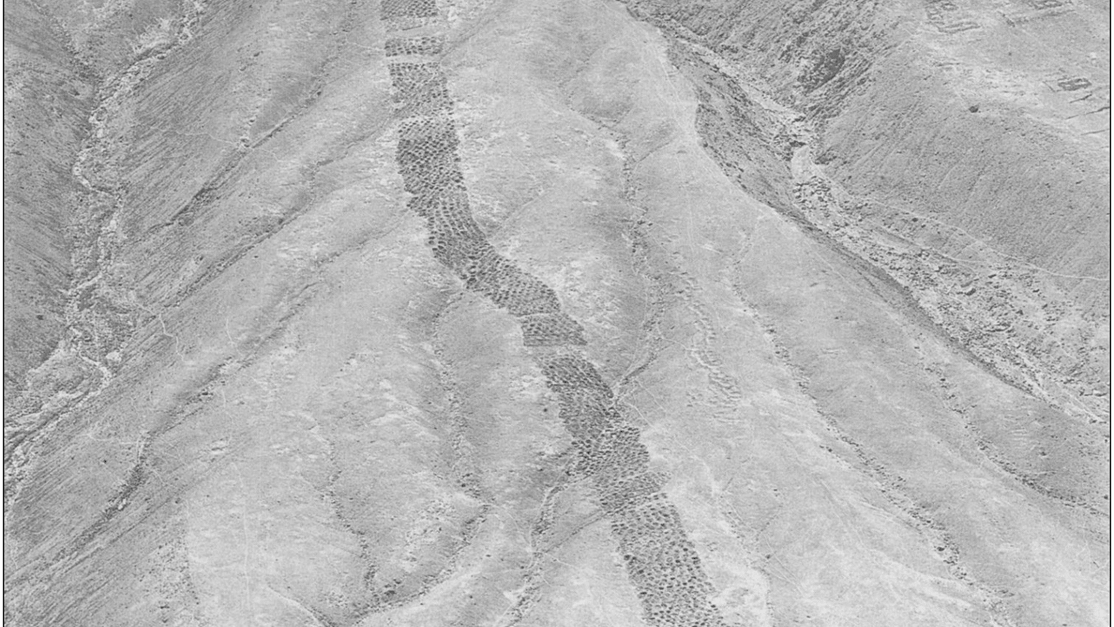
Approximately 5,200 holes arranged across a desert hillside in southern Peru may have formed an ancient system for exchanging goods and recording tribute payments. Known as Monte Sierpe, or the “Band of Holes,” the 1.5-kilometer-long structure has puzzled archaeologists for decades. An investigation of its unusual layout and microscopic plant remains now suggests that it may have served as a marketplace before becoming part of the Inca Empire’s administrative system.
An international research team led by Jacob L. Bongers of the University of Sydney examined the site using drone mapping, sediment analysis, and comparisons with Andean record-keeping practices. Their findings, published in the journal Antiquity, provide new evidence for an economic function previously proposed by archaeologists Charles Stanish and Henry Tantaleán.
Traces of Crops Inside the Desert Holes
Monte Sierpe lies in Peru’s Pisco Valley, approximately 35 kilometers from the Pacific coast. Its thousands of carefully aligned depressions became widely known after aerial photographs appeared in 1933.
The holes measure between one and two meters across and reach depths of up to one meter. Some have partial stone walls, while others were excavated directly into the hillside.
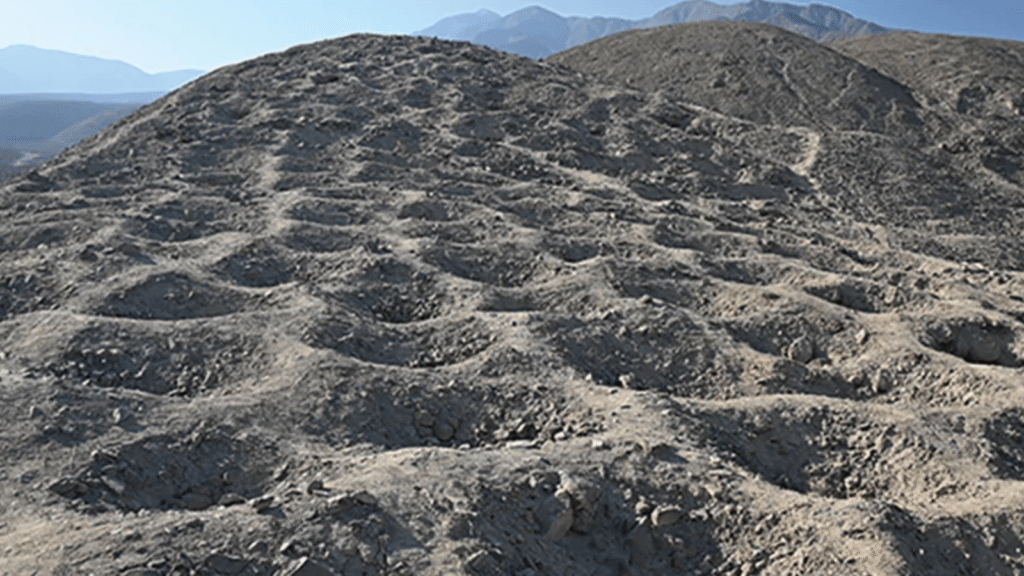
To investigate their purpose, researchers collected sediment from 19 holes and two nearby control locations. Microscopic analysis identified maize pollen, squash starch grains, amaranth remains, and traces of other plants associated with the local environment.
Maize pollen was particularly significant because it is not typically dispersed over long distances by wind. Its presence in several holes suggests that people may have deliberately brought agricultural products to the site.
The researchers also identified willow and bulrush, plants traditionally used to produce baskets, mats, and other containers. These remains raise the possibility that goods arrived in woven baskets or bundles, leaving traces of plant material behind.
Not every botanical trace necessarily dates to the site’s original use. Some pollen may have arrived naturally or during later periods, making the evidence suggestive rather than conclusive.
Thousands of Holes Arranged in Numerical Patterns
Detailed drone surveys revealed that Monte Sierpe consists of at least 60 sections, separated by open spaces and distinguished by the number and arrangement of their holes.
Some sections display striking numerical regularity. One contains at least nine consecutive rows of eight holes, while another has six rows of seven followed by a row of eight, producing a total of 50.
Elsewhere, researchers identified at least 12 rows alternating between seven and eight holes. Such arrangements suggest deliberate organization, potentially related to counting or separating quantities of goods.
The spaces between sections may also have helped people move across the hillside while depositing or retrieving materials.
A charcoal sample recovered from one hole produced a radiocarbon date of AD 1320–1405. Pottery discovered at the site provides additional evidence of activity during the Late Intermediate Period and subsequent Inca rule.
These findings place Monte Sierpe within a period of major political and economic changes in southern Peru.
From a Chincha Marketplace to Inca Administration
Before the Inca conquest in the fifteenth century, the Pisco Valley belonged to the Chincha Kingdom, a powerful coastal society whose agricultural economy benefited from seabird guano, according to recent isotopic research.
Historical accounts describe Chincha communities specializing in fishing, farming, craftsmanship, and trade. Merchants traveled along the coast and into the Andean highlands, exchanging goods between regions with different resources.
Monte Sierpe stood near the intersection of important pre-Hispanic routes connecting these communities. Its location, combined with evidence of agricultural products, supports the possibility that people gathered there to exchange goods.
Under this interpretation, individual holes may have held designated quantities of products, allowing participants to assess supplies and organize exchanges.
However, archaeologists have not identified nonlocal trade goods at the site. If Monte Sierpe operated as a marketplace, the available evidence points primarily toward exchanges involving locally produced commodities.
The structure may have acquired a different function after the Inca incorporated the Chincha Kingdom into their expanding empire.
Inca administrators maintained records of population, agricultural production, and labor obligations through a sophisticated system that included khipus, devices made from knotted cords.
Researchers noticed similarities between the organized sections at Monte Sierpe and an Inca-style khipu discovered near Pisco, now preserved at Berlin’s Ethnologisches Museum.
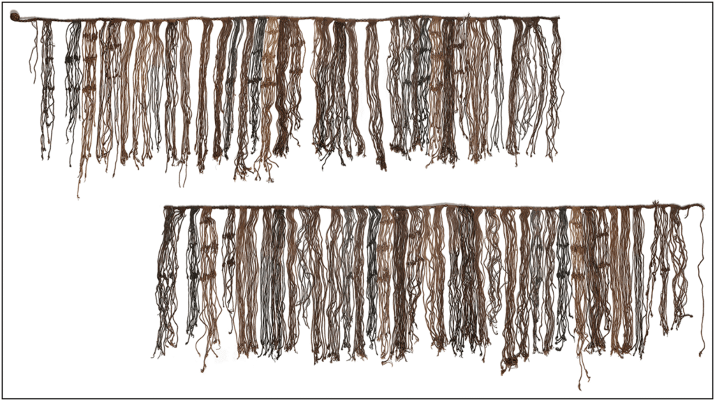
The khipu contains 80 distinct groups of pendant cords, most consisting of 10, 11, or 12 cords. Although its numerical patterns do not directly match those of Monte Sierpe, both demonstrate systematic grouping consistent with administrative record-keeping.
The researchers propose that individual sections of the hillside could have represented communities responsible for delivering goods or fulfilling tribute obligations.
In this scenario, Monte Sierpe became a place where agricultural products were collected, counted, and redistributed under Inca supervision.
An Economic System Built into the Landscape
The findings provide limited support for earlier interpretations of Monte Sierpe as a defensive structure, burial ground, mining site, or water-collection system. Instead, its location, botanical remains, and numerical organization point toward activities involving exchange and accounting.
The interpretation remains a working hypothesis. Further excavations, radiocarbon dating, and comparisons with regional khipus will be necessary to establish how the structure operated and whether its purpose changed over time.
Nevertheless, the research presents a compelling possibility: communities in the ancient Andes may have transformed an entire hillside into a system for organizing economic activity, using thousands of excavated holes to manage goods long before written administrative records became common in the region.
Cover Image: Aerial view of Monte Sierpe in Peru’s Pisco Valley, where approximately 5,200 holes extend across a desert hillside. Researchers suggest the site may have served as an ancient marketplace and accounting system. Photo: Robert Shippee / American Museum of Natural History, AMNH Library (1933).