In September 1176, a large Byzantine army advanced into Anatolia with siege engines, supply wagons and ambitions of restoring imperial control over the region. Along its route, the soldiers passed the lost castle now associated with Myriokephalon before entering a confined valley where Seljuk forces launched an attack that changed the balance of power in Anatolia.
The fortress later faded from historical memory, and its location remained uncertain for nearly 850 years. Researchers now believe they may have identified its remains above the Kufi Valley near Çivril in Denizli Province, western Türkiye.
The proposed site contains extensive walls, towers, possible cisterns and pottery spanning several centuries. Its position also corresponds closely to the route recorded by Byzantine historian Niketas Choniates, according to Professor Hasan Kara and Associate Professor İbrahim Balık.
Their findings were published in the Journal of Anatolian Cultural Research in December 2024. The researchers brought the proposed discovery to wider public attention ahead of the 850th anniversary of the Battle of Myriokephalon.
The missing landmark from a decisive battle
On September 17, 1176, the forces of Byzantine emperor Manuel I Komnenos confronted the army of Seljuk sultan Kilij Arslan II. Manuel hoped to weaken the Seljuk Sultanate of Rum and re-establish Byzantine authority across the Anatolian interior.
Instead, the imperial column was attacked while moving through difficult terrain. Its siege equipment was lost, many soldiers were killed and Manuel was forced to negotiate his withdrawal.
The defeat did not immediately end Byzantine power in Anatolia, but it seriously weakened the empire’s attempt to reverse the political changes that had followed the Battle of Manzikert in 1071. Myriokephalon became a major milestone in both Byzantine and Turkish history.
Yet the exact location of the battle remains disputed. Historians have proposed sites across the modern Turkish provinces of Denizli, Isparta, Afyonkarahisar and Konya, but no location has achieved universal acceptance.
Finding the ruined castle mentioned in Byzantine accounts could narrow the search considerably. Because Manuel’s army passed the fortress shortly before entering the battlefield, its location provides an important geographical clue.
Following the route of Manuel’s army
Kara and Balık began conducting fieldwork around Çivril in 2010. Rather than searching for a standing medieval fortress, they looked for an older abandoned settlement positioned along the route described in historical sources.
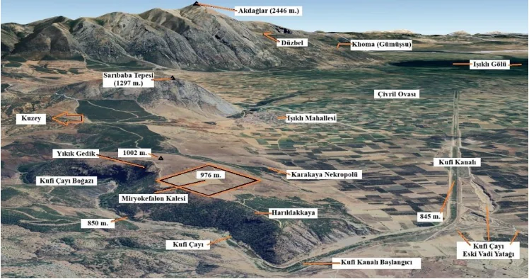
Choniates’ account places the Byzantine army first at Homa, generally associated with modern Gümüşsu. After passing Myriokephalon, the column entered a long defile where the road became increasingly narrow.
The researchers argue that this description corresponds closely to the Kufi Valley. Extending for roughly 10 miles, the valley formed a natural route between the Çivril and Sandıklı plains and offered passage toward the Anatolian interior.
This interpretation placed the most likely location of the castle near the point where the valley opens onto the Çivril Plain. Fieldwork around the Harıldakkaya and Karakaya hills subsequently revealed a large settlement on elevated ground between Koçak and Işıklı.
Walls, towers and cisterns above the valley
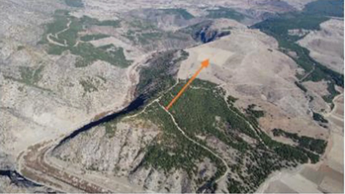
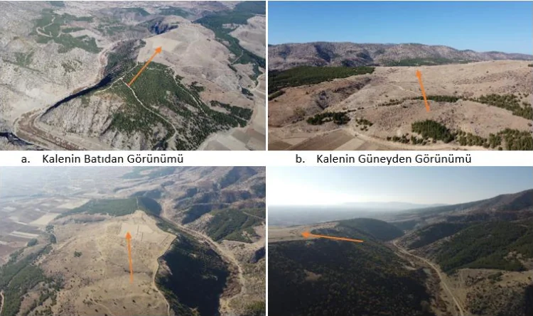
The site rises approximately 100 to 120 metres above the surrounding plain. From this position, its inhabitants could have monitored movement across the agricultural lowlands and through the entrance to the Kufi Valley.
Researchers documented wall foundations continuing for dozens of metres, two towers and stone blocks belonging to several structures. Possible cisterns or wells, quarry traces, roof tiles and large quantities of pottery were also recorded.
According to Kara, the densest concentration of remains covers more than 15 hectares. When its wider boundaries are considered, the settlement may have extended across nearly 30 hectares, making it far larger than an isolated watchtower or small roadside fort.
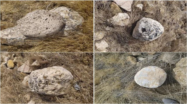
Worked stone spheres of several sizes were also documented across the site. The researchers suggest that some may have served as defensive projectiles, although their original function has not been conclusively established.
A castle that was already ancient in 1176
The pottery does not point to a fortress constructed for Manuel’s campaign. Surface finds instead indicate several periods of settlement stretching from the fourth century BC to the sixth century AD.
This chronological gap may support one aspect of the identification. Byzantine accounts describe Myriokephalon not as an active 12th-century stronghold, but as an old and ruined castle used as a landmark along the army’s route.
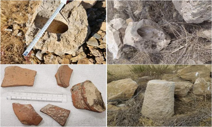
Kara and Balık propose that the remains belonged to a Roman or possibly pre-Roman settlement abandoned centuries before the battle. Its walls may still have been prominent enough in 1176 for travellers and military chroniclers to recognise the place.
The area had attracted official archaeological attention before the identification was announced. After a cemetery was recorded nearby in 2020, the location was registered the following year as the Karakaya Necropolis and Settlement by the Aydın Regional Board for the Conservation of Cultural Heritage.
A compelling identification, but not yet proof
No inscription naming Myriokephalon has been documented at the settlement, and the published evidence includes no archaeological material directly connecting the site with the battle of 1176. The proposed identification instead relies on several lines of evidence considered together.
These include the ancient fortifications, the settlement’s commanding position, its proximity to Homa and the correspondence between the Kufi Valley and the route described by Choniates. Together they make the Çivril site a significant candidate, but they do not settle the wider debate.
Balık has acknowledged that competing interpretations remain. More extensive surveys and archaeological excavations will be required to determine whether the ruins can be securely identified as the lost Myriokephalon Castle.
Excavation could establish when the fortifications were constructed, how long the settlement remained occupied and whether it was still recognisable as a castle during the Middle Ages. Until firmer evidence emerges, the ruins above the Kufi Valley remain a compelling candidate for the long-lost landmark described in Byzantine accounts.
Cover Image: Aerial view of the elevated settlement near Çivril proposed as the long-lost Myriokephalon Castle. Credit: H. Kara Archive / Kara and Balık (2024)