A city that once stood at the crossroads of continents has quietly returned to the map of ancient history. For generations, historians knew its name but not its place. Alexandria on the Tigris, a metropolis founded in the age of Alexander the Great and long described as a vital gateway between Mesopotamia and the Indian Ocean, seemed to have vanished without a trace. Rivers shifted, coastlines moved, and centuries of conflict erased its visible remains. Today, that silence has been broken. An international research team led by Stefan Hauser of the University of Konstanz has now conclusively identified and reconstructed the city’s location, scale, and historical role. Their findings reveal not just a lost settlement, but one of antiquity’s most important engines of global trade. A Port City Born from a Strategic Crisis The story begins in the late fourth century BCE, during the eastern campaigns of Alexander the Great. As his armies crossed from the Indus region back toward Mesopotamia, Alexander encountered an unexpected logistical problem. Sedimentation was steadily choking southern Mesopotamian harbors, pushing the Persian Gulf farther south and rendering existing ports ineffective. The solution was bold. Near the junction of the Tigris River and the Karun, Alexander ordered the construction of a new port city—positioned to bridge inland river traffic with maritime routes. Known later as Charax Spasinou, the city appeared sporadically in Roman texts and distant inscriptions, but its physical footprint was lost to time. From Aerial Shadows to Ground Truth The first modern clues surfaced in the 1960s, when aerial photographs revealed massive linear features in southern Iraq. Political instability, however, froze research for decades. The suspected site—today called Jebel Khayyaber—lay in a militarized border zone and even served as a base during the Iran–Iraq War. Only after 2014 did conditions allow archaeologists to return. What they found exceeded expectations: kilometers of surviving city walls, in some places still rising eight meters high. Soon after, Hauser joined the project, bringing together archaeology, geophysics, and landscape analysis under unusually restrictive security conditions. With excavation largely impossible, the team turned to non-invasive methods. Over years of systematic walking surveys, they documented thousands of surface finds. Drone mapping produced high-resolution terrain models. Cesium magnetometers traced what lay beneath the soil—streets, canals, buildings, and industrial installations—without turning a single spade. The emerging picture was unmistakable. Alexandria on the Tigris was not a modest harbor. It was a monumental, carefully planned city. An Eastern Twin to Alexandria in Egypt Hauser describes the city as the eastern counterpart to Alexandria on the Mediterranean. Both were founded at river mouths, both linked inland economies to overseas trade, and both functioned as geopolitical gateways. For more than five centuries, Alexandria on the Tigris controlled the flow of goods between Mesopotamia, India, and regions reaching as far as Central Asia and China. Geophysical surveys revealed enormous residential blocks laid out in a grid extending far beyond the city’s main walls. Yet the plan was not uniform. At least four different orientations suggest multiple construction phases and specialized districts. Archaeologists identified dense housing zones, temple complexes, workshops with kilns and metalworking furnaces, and a canal-linked inner harbor embedded within the urban fabric. North of the city, satellite imagery exposed a vast irrigation network, pointing to large-scale grain production capable of sustaining a substantial population. The Beating Heart of Indo-Mesopotamian Trade Between roughly 300 BCE and 300 CE, long-distance trade intensified dramatically. Along the Tigris, imperial capitals such as Seleucia and Ctesiphon grew into megacities with immense appetites for foreign goods. According to Hauser, nearly all commerce arriving from India passed first through Alexandria on the Tigris—even after newer ports emerged farther south. Its dominance rested on geography. Goods could be transferred seamlessly from seagoing vessels to river transport, making the city indispensable despite environmental challenges that continued to reshape the coastline. When the River Turned Away Ultimately, the same forces that gave Alexandria its power sealed its fate. Geological evidence shows that the Tigris gradually shifted westward, severing the city’s access to navigable water. By the third century CE, the shoreline of the Persian Gulf lay almost 180 kilometers to the south. Cut off from trade routes, the city lost its strategic purpose and was slowly abandoned. Its role did not disappear entirely. Centuries later, Basra would rise nearby, inheriting Alexandria’s function as the region’s principal port—without knowing the full extent of what came before. Rethinking Ancient Globalization Supported by the Gerda Henkel Foundation, the German Research Foundation, and the British Council’s Cultural Protection Fund, further research is now planned. Much of the city remains unexplored, buried beneath sediment and memory. Yet even without large-scale excavation, Alexandria on the Tigris is already reshaping how scholars understand ancient globalization. It was not a peripheral outpost, but a central hub—proof that long before the modern world, complex international trade networks bound continents together through cities that could vanish as completely as they once flourished.

The Port That Connected Mesopotamia to India: Archaeologists Rediscover Alexandria on the Tigris

A city that once stood at the crossroads of continents has quietly returned to the map of ancient history. Long forgotten beneath shifting rivers, modern borders, and decades of conflict, Alexandria on the Tigris was a major port founded in the age of Alexander the Great, controlling the flow of trade between Mesopotamia, India, and the wider ancient world.

For generations, historians knew the city’s name but not its location. Described in ancient sources as a vital gateway between Mesopotamia and the Indian Oceanthe metropolis seemed to have vanished without a trace. Rivers shifted, coastlines retreated, and centuries of conflict erased its visible remains. Today, that silence has finally been broken.

An international research team led by Stefan Hauser of the University of Konstanz has now conclusively identified and reconstructed the city’s location, scale, and historical role. Their findings reveal not just a lost settlement, but one of antiquity’s most important engines of global trade.

A Port City Born from a Strategic Crisis

The story begins in the late fourth century BCE, during the eastern campaigns of Alexander the Great. As his armies crossed from the Indus region back toward Mesopotamia, Alexander encountered an unexpected logistical problem. Sedimentation was steadily choking southern Mesopotamian harbors, pushing the Persian Gulf farther south and rendering existing ports ineffective.

The solution was bold. Near the junction of the Tigris River and the Karun, Alexander ordered the construction of a new port city—positioned to bridge inland river traffic with maritime routes. Known later as Charax Spasinou, the city appeared sporadically in Roman texts and distant inscriptions, but its physical footprint was lost to time.
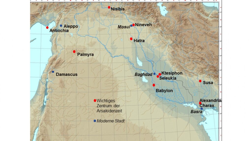
Location of Alexandria/Charax. Credit: Stefan R. Hauser

From Aerial Shadows to Ground Truth

The first modern clues surfaced in the 1960s, when aerial photographs revealed massive linear features in southern Iraq. Political instability, however, froze research for decades. The suspected site—today called Jebel Khayyaber—lay in a militarized border zone and even served as a base during the Iran–Iraq War.

Only after 2014 did conditions allow archaeologists to return. What they found exceeded expectations: kilometers of surviving city walls, in some places still rising eight meters high. Soon after, Hauser joined the project, bringing together archaeology, geophysics, and landscape analysis under unusually restrictive security conditions.

With excavation largely impossible, the team turned to non-invasive methods. Over years of systematic walking surveys, they documented thousands of surface finds. Drone mapping produced high-resolution terrain models. Cesium magnetometers traced what lay beneath the soil—streets, canals, buildings, and industrial installations—without turning a single spade.

The emerging picture was unmistakable. Alexandria on the Tigris was not a modest harbor. It was a monumental, carefully planned city.

An Eastern Twin to Alexandria in Egypt
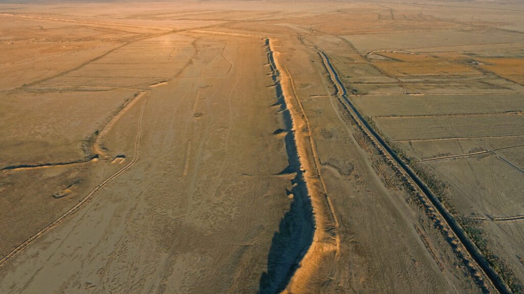
Still impressive today: the fortification walls of Alexandria. Credit: © Charax Spasinou Project – Stuart Campbell, 2017

Hauser describes the city as the eastern counterpart to Alexandria on the Mediterranean. Both were founded at river mouths, both linked inland economies to overseas trade, and both functioned as geopolitical gateways. For more than five centuries, Alexandria on the Tigris controlled the flow of goods between Mesopotamia, India, and regions reaching as far as Central Asia and China.

Geophysical surveys revealed enormous residential blocks laid out in a grid extending far beyond the city’s main walls. Yet the plan was not uniform. At least four different orientations suggest multiple construction phases and specialized districts. Archaeologists identified dense housing zones, temple complexes, workshops with kilns and metalworking furnaces, and a canal-linked inner harbor embedded within the urban fabric.

North of the city, satellite imagery exposed a vast irrigation network, pointing to large-scale grain production capable of sustaining a substantial population.

The Beating Heart of Indo-Mesopotamian Trade

Between roughly 300 BCE and 300 CE, long-distance trade intensified dramatically. Along the Tigris, imperial capitals such as Seleucia and Ctesiphon grew into megacities with immense appetites for foreign goods. According to Hauser, nearly all commerce arriving from India passed first through Alexandria on the Tigris—even after newer ports emerged farther south.

Its dominance rested on geography. Goods could be transferred seamlessly from seagoing vessels to river transport, making the city indispensable despite environmental challenges that continued to reshape the coastline.

When the River Turned Away

Ultimately, the same forces that gave Alexandria its power sealed its fate. Geological evidence shows that the Tigris gradually shifted westward, severing the city’s access to navigable water. By the third century CE, the shoreline of the Persian Gulf lay almost 180 kilometers to the south. Cut off from trade routes, the city lost its strategic purpose and was slowly abandoned.

Its role did not disappear entirely. Centuries later, Basra would rise nearby, inheriting Alexandria’s function as the region’s principal port—without knowing the full extent of what came before.

Rethinking Ancient Globalization

Supported by the Gerda Henkel Foundation, the German Research Foundation, and the British Council’s Cultural Protection Fund, further research is now planned. Much of the city remains unexplored, buried beneath sediment and memory.

Yet even without large-scale excavation, Alexandria on the Tigris is already reshaping how scholars understand ancient globalization. It was not a peripheral outpost, but a central hub—proof that long before the modern world, complex international trade networks bound continents together through cities that could vanish as completely as they once flourished.

University of Konstanz

Cover Image Credit: Charax Spasinou Project 2022 (Robert Killick)