A vast digital reconstruction of the Roman Empire’s road network—covering nearly 180,000 miles—has just been completed, revealing the empire’s highways with unprecedented accuracy. The ambitious project, named Itiner-e, stands as the most comprehensive digital atlas ever created for the ancient world.
Built by an international team of more than twenty researchers, the model visualizes how people and goods moved across an empire that, at its height around 150 CE, stretched from Britain to Morocco and from Spain to Syria. The study adds over 60,000 miles of newly mapped routes, reshaping what we know about Roman infrastructure.
Unlike earlier maps based on low-resolution data, Itiner-e integrates archaeological evidence, historical texts, topographical models, and satellite imagery. The result is a high-precision dataset that adjusts ancient road routes to real terrain—tracing the winding paths over the Pyrenees, the Alps, and the rugged mountains of Greece and Anatolia.
According to the researchers, roughly one-third of the network consisted of well-engineered Roman highways (viae publicae), while the rest were secondary or local roads—the equivalents of today’s B roads. However, only about 2.7 percent of these routes are confirmed archaeologically; the rest are reconstructed from multiple data sources.
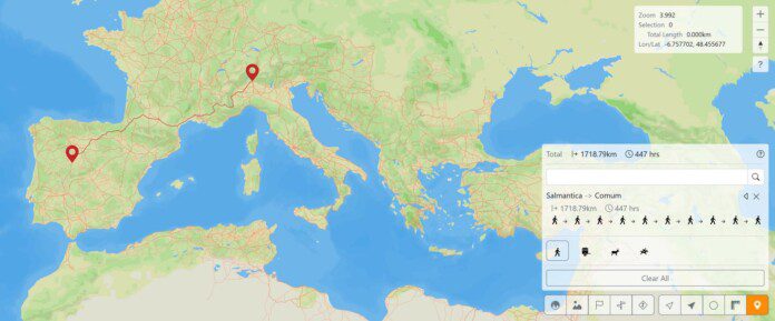
For example, a journey from Salmantica (modern Salamanca) in Spain to Comum (Como) in northern Italy would have taken nearly 447 hours on foot—an astonishing simulation that shows how Itiner-e can model real-world travel conditions of antiquity.
Beneath the digital model lies a reminder of Rome’s exceptional engineering. Each road began with a trench cut down to solid ground, then layered with rubble, gravel, and lime concrete before being paved with stones fitted so tightly that many sections still survive today. The roads were built in a subtle arch for drainage, and in cities like Timgad in modern Algeria, some even had two lanes—a familiar sight for modern drivers.
By merging archaeology with big data, Itiner-e doesn’t just recreate ancient geography—it redefines how we visualize imperial connectivity, trade, and administration across one of history’s most complex empires.
Cover Image: Itiner-e screengrab